
New York is a modern metropolis home to millions of people who consume vast amounts of goods and services daily. This also means the city produces significant amounts of waste, noise, dirt, and poor-quality air as a result of human activity. To combat these challenges, the city government is developing new parks, renovating old ones, promoting public transportation, encouraging the use of electric vehicles, and urging citizens to conserve electricity. But does this really help? Not much, especially when you look at the air quality map of New York City overall and the Bronx in particular. Bronxname offers a closer look at this issue.
Modern Air Quality Measurement Tools That Highlight the Problem
As noted by medium.com, living in New York offers many benefits. The city boasts one of the world’s best public transport systems and provides opportunities for work, recreation, dining, and exercise at any time of day or night. However, all this convenience comes at a cost: the lack of peace and quiet. It’s nearly impossible to find a tranquil corner or moment of solitude, surrounded as you are by an unrelenting world of sounds, smells, and vibrations. This constant activity contributes to significant disparities in air quality across the city’s boroughs and neighborhoods.
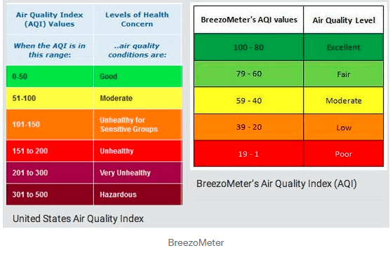
To better understand the problem, researchers use tools like the BreezoMeter. This tool calculates the Air Quality Index (AQI), a standardized scale that ranges from 0 (poor air quality) to 100 (excellent air quality), and categorizes air quality into five uniform levels. BreezoMeter compiles data from local research conducted according to specific standards, accounting for the concentration of various pollutants in the air worldwide. Although AQI systems vary by country, BreezoMeter offers a standardized benchmark for international comparisons. The goal is simple: to make air quality data more comprehensible and accessible to the public.
Air Quality on Manhattan and Staten Island Compared to the Bronx
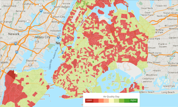
How does New York fare in terms of air quality? Unfortunately, the map reveals a lot of red zones, indicating poor air conditions. These “red hotspots” are as numerous as acne spots on a teenager’s face. Let’s identify the most problematic areas.
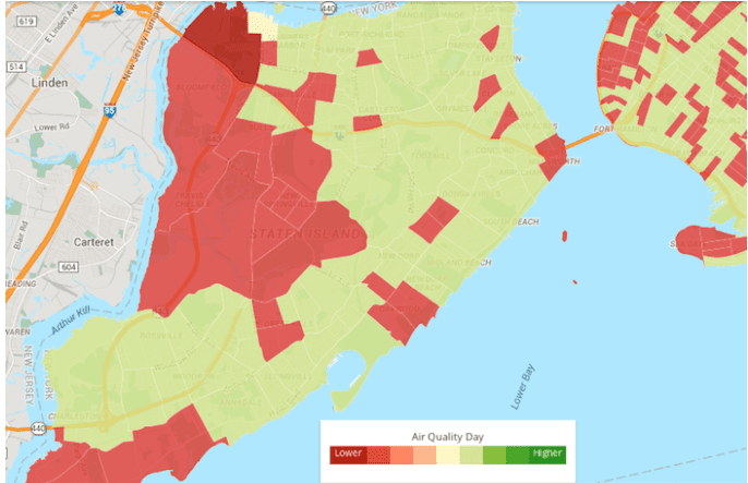
Staten Island’s western shore ranks among the worst offenders. Today, this area serves as a hub of industrial activity with only one residential neighborhood. In the past century, it hosted even more industrial enterprises, including oil refining and construction facilities. Currently, it’s home to the large Con Edison power plant and Teleport, a high-tech industrial park built in the 1980s.
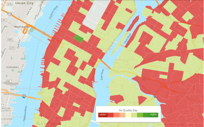
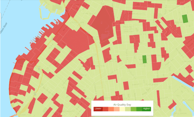
Manhattan is another major contributor to poor air quality. Large stretches of the borough along the Hudson River appear red on the map, potentially due to their proximity to New Jersey and other densely populated areas like East Village, West Village, Lower East Side, and Tribeca. Surprisingly, there’s a bright green square amidst this sea of red. Can you guess what it is? It’s Times Square, oddly enough, a relatively cleaner part of the city.
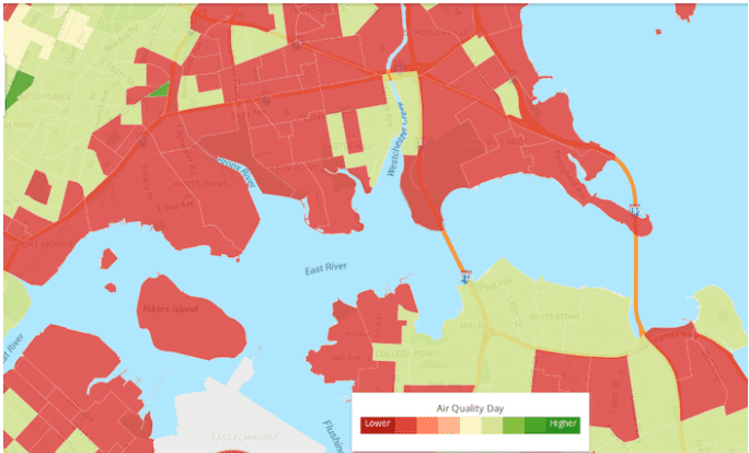
Rikers Island, known for its infamous prison complex, is also marked in red due to its air quality issues.
Air Quality in the Bronx and the Importance of Hunts Point
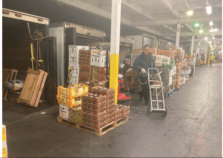
In the Bronx, Hunts Point stands out as a major source of pollution. This area, historically an industrial hub, became home to a massive food market in 1967 and a meat market in 1974.
In June 2023, the New York State Assembly allocated $130 million to modernize Hunts Point’s commercial infrastructure. Additionally, the city pledged another $130 million, federal grants would contribute $135 million, and private developers would invest $250 million. The goal is to make this area more environmentally friendly and compliant with environmental regulations. Why such attention to this market? By June 2022, Hunts Point’s food, fish, and meat markets supplied 12% of New York City’s food supply. Specifically, the food market provided 25% of the city’s produce, the meat market accounted for 35% of the city’s meat supply, and the fish market delivered 45% of the city’s seafood. Altogether, the commercial facilities here span over one million square feet.
Plans for Improving Air Quality in the Bronx
The redevelopment project will transform Hunts Point into a modern complex with 800,000 square feet of cold storage and 200,000 square feet of additional facilities. These changes will ensure compliance with the U.S. Food and Drug Administration’s food safety modernization standards, ultimately improving air quality. Reducing the influx of thousands of diesel trucks passing through the Bronx daily will play a significant role in this improvement. The project also includes plans to increase the use of electric trucks and install EV charging stations at the market.
In addition, the rail system serving Hunts Point will be upgraded, enabling trains to transport more goods and further reducing reliance on trucks.
When can Bronx residents expect cleaner air? Not immediately. The project is slated for completion by September 2025, with construction beginning in late 2025 or early 2026. Nevertheless, the initiative is a step forward. According to officials, the investment will safeguard union jobs, improve the health of local residents, and strengthen food supply chains at various levels. Assembly Member Amanda Septimo emphasized that the improvements will enhance air quality, boost business growth, and establish a community-oriented food distribution plan.
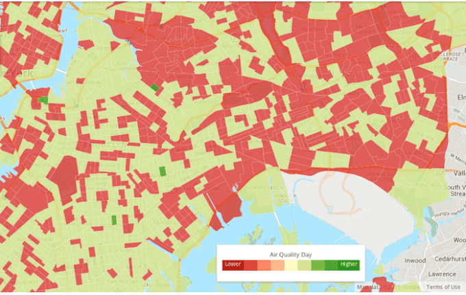
Air Quality in Queens and Northern Brooklyn
In Queens, areas around JFK Airport face significant pollution issues. The region appears blank on the air quality map, perhaps because it couldn’t be classified as worse than it already is. Adjacent areas and the red hotspot near Maspeth further confirm the low air quality in this region. However, exceptions exist: Queens has one of the few dark green spots on the map, located near Seneca Avenue between Stanhope Street and Menahan Street.
In Northern Brooklyn, air quality is relatively better, but it worsens further south. Areas around Bay Ridge and the Brooklyn Army Terminal suffer from significant pollution due to warehouses, offices, piers, cranes, rail tracks, and loading equipment in Sunset Park.
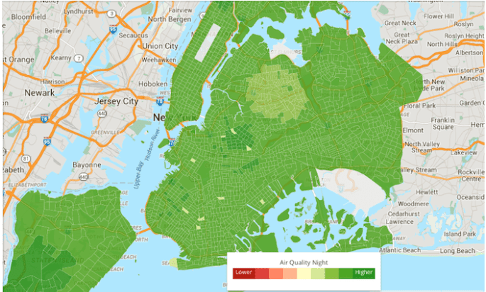
A Glimmer of Hope
Is the situation entirely bleak? Not necessarily. A look at the nighttime AQI map of New York reveals a city slowly breathing easier. With continued efforts and investment, New York may yet achieve cleaner air for its residents.